Saturday, December 31, 2011

2011 12-31 Daisy Mountain


Length: 8.7 miles

Duration: 6 Hours 11 minutes

Vertical Up: 3491 feet

My track log at EveryTrail


I've been lazy lately. A recent bought with the flu combine with the dark, dark mornings of winter have conspired to keep me away from the treadmill in the morning.  Combine that with a few good holiday meals and I've become quite a slug.  I know I've put back on some weight but I'm too chicken to see how much.

Since the year was drawing to a close, I decided to end this year of transformation with a hike to the same place my year began - Daisy Mountain.  I wanted to hike with some new friends and neighbors so I put out the notice that I was hiking.  I was happy that six others decided to spend the last day of the year hiking up to the summit with me.


I wanted to start the morning at first light so we agreed to meet at 7:30.  As described here a couple of times, the hike starts out with about 1 1/2 miles of flat hiking.  I have come to name this portion the "Parkside Penalty".  As it turns out, if you start the hike up Daisy Mountain from the Anthem Country Club, you can avoid this long, monotonous section of the hike.


Since I've described the hike a few times in this blog, I'm not going to go into details about the hike.  The part of the hike that was interesting today was that I was one of the stronger hikers (and I'm not use to that).  So the journey up to the summit was a mixture of tough verticals, tour guide and cheerleader.  After a few hours we had all made it to the saddle area just below the first summit.  This is where we shared water with two ladies hiking to the top with NO WATER.  It always amazes me to see people hiking with nothing.


After a short steep hike we reached the summit.  It was such a beautiful day for hiking.  This is the kind of day that I envision people taking brochure pictures for Anthem.  After a short lunch break we headed down.  The downhill leg was filled with a bit of excitement as one of our party decided it may be quicker to roll down the mountain.  After thinking better, she grabbed a rock to stop her fall.  Luckily all we had to deal with were scrapes and bruises - nothing broken!

The fall slowed our decent somewhat as we were being extremely careful on the steep areas.  About halfway down we stopped at our last geocache.  this was where I heard from Jim and his 9 year old daughter.  We had though they turned around at the saddle but they pressed on and made it to the summit.  Quite an achievement for a 9 year old!  Knowing they had to come down the backside (and because I was their ride home), I said goodbye to the main group and went back to hike with Jim.


We met at another cache up the hill and made our way back down, through the "Parkside Penalty" and back to the car.

This was a great hike and a fabulous way to end 2011!

Sunday, December 11, 2011

2011 12-11 Skull Mesa


Length: 11 miles

Duration: 7 Hours 19 minutes

Vertical Up: 3684 feet

My track log at EveryTrail


About two years ago I went on a hike to Skull Mesa.  The hike was described with the following disclaimer “The terrain can and will be difficult at times so be prepared. The hike might take anywhere from 6 - 8 hours depending on how fast (or slow) we hike.”  I never made it to the top of Skull Mesa and the group ended up finishing the hike 10 hours later in the dark.

This failure has weighed on my mind for a while.  I’ve wanted to try this hike again now that I am in a little better physical shape.  With the help of a hiking club I am a member of, I arranged a geocache event to Return to Skull Mesa.

The Skull Mesa hike can be broken up into three legs: Hiking the river, hiking across to the base and the final assent to the summit.  A better description of the route can be found at the Hike Arizona site

View of Skull Mesa from the Parking Area


Hiking the River


Looking back at Cottonwood Creek
The group met at 8 AM at the parking area of the Spur CrossRanch Conservation Area on a particularly cold morning in December.  In all, seven people and two dogs were brave enough to start hiking with temperatures in the 40s.  At the start of our hike, the sun had not peaked over the surrounding hills and the wind was whipping around.  It was cold.

We all paid our $3.00 and began the first leg of the hike. This leg follows Spur Cross Road as it crosses Cottonwood Creek.  It is a well maintained trail and is part of the Maricopa Trail System.  Two miles and a few creek crossings later we arrived at the trailhead of the next leg of our hike.


Hiking Across to the Base

Skull Mesa is getting Closer


After finding a geocache, we started our hike on the Cave Creek Trail System.  We briefly followed Cave Creek trail #4 (for about 500 feet), then took a right onto trail Cottonwood Trail #247.  Cottonwood trail took us east cross country for approximately 4 miles.  This portion of the hike followed the terrain of the hills with several assents and descents mixed in.


Hikers finding a cache


The last mile or so of this portion is a pretty steady climb to the base of Skull Mesa Summit trail.  As it turns out, this four mile stretch takes a whole lot out of you.  The switchbacks and constant climbing and descending never quite allow you to catch your breath. 

It took us about two hours to hike the four miles to the base of Skull Mesa.  When you reach the trail, there is a gate with a pretty cool self-closing weight.  At this point we rested for 15 minutes before beginning the climb to Skull Mesa


The Final Assent


Skull Mesa Trail (#248) is 1.2 miles of pure hell.  The trial begins nice enough with a steady climb passing some ancient petroglyphs.  About a quarter mile in, the climb starts – and boy does it climb.  I’m no expert in rating a climb, but, I got to say that an 1100 foot assent in one mile is tough – really tough.  Two years ago, I quit this hike about ½ mile into the climb.  Today I was a better man and slowy made my way to the top.

The Summit


For those crazy enough to make it to the top, you are reward with SPECTCULAR views of the north valley.   Today was a hazy day but the views were still awesome.  We spent about ½ hour on top eating lunch and resting up.  This was a proud moment for me as I was able to conquer something that I could not do just one year ago. 


The Skull Mesa Cache is a very cool cache with a few resident travel bugs and it even hides a real skull.


After resting up, we decided to pass on exploring the mesa and beginning the descent down.   Although the descent is not tough on the lungs, it sure is tough on the legs.  Basically you are in a control fall for most of the way back to Cottonwood Creek.  I welcomed the few uphill portions on the way back.  It probably is hard for non-hikers to understand but I really prefer climbing over descending.  Sure it’s tougher on the muscles, but, it is easier on the knees.


If you like hiking I would recommend this hike.  It’s not for everyone and should be considered strenuous.   I can’t wait to go back (when I am a bit stronger) and explore the backside (north) of the Mesa.  I understand there are some Indian Ruins back there.

Sunday, November 13, 2011

2011 11-13 Peralta Trail - Superstition Wilderness


Length: 11.6 miles

Duration: 6 Hours 15 minutes

Vertical Up: 5495 feet

My track log at EveryTraill


This my first time hiking in the Superstitions and it will not be my last.   This is a beautiful area and so much different than other areas around the valley.  The hike was put on through one of the hiking meet up groups I belong to.  It was originally supposed to be a short 5 1/2 mile hike with a view of Weaver's Needle and some caves on the way back.  Those plans changed.

On the morning of the hike I woke up to pouring rain at my house - not the best hiking weather.  However, since Anthem is at least 60 miles away from the Superstitions, I knew the weather would be different.  I met up with the group and we drove to the trailhead.  Because of the rain, the group turned out to be only 3 of the 5 people that signed up for the hike.


At the trail head it was drizzling and cold.  Since 99% of my hikes are in hot weather, this was a welcome change.  While we were there we talked to the ranger about the trail conditions and the different options we had to extend the hike.  We found out that the hike all the way around Weaver's needle was 12 - 15 miles.  We made this our goal (and I snapped a picture of the map).


The first 2 1/2 miles of the hike was a steady 1100 foot assent for 2 1/2 miles up to about 3800 feet.  Along the way we were bombarded by a steady drizzle and rewarded with spectacular views of the surrounding mountains.


At the summit of this section we were treated to our first view of the Weaver's needle.  This was where the original hike was supposed to turn and head back down the Cave Trail.  Since we were just warming up and had 3 strong hikers , we decided to press on and hike all the way around Weaver's Needle.

Weaver's Needle in the Rain

The next section of the hike was a steady 3 1/2 mile decent keeping the needle on our right (to the east).  There were several points where we stopped to study the map, our surroundings and the trail to make sure we were going the right way.  Soon enough we reached the northern end of our hike at the base of Black Top Mesa.  This is where the hike turned east.  Interesting not here, from the map at the trail head, we knew the trail numbers we were supposed to follow.  When we reached this turn, the sign did not have the numbers, only the name of the trail.


We followed the base of Black Top Mesa east for a short hike and got a view of Weaver's needle from the north.  After a short stop for lunch, we turned south to head back down a new trail back to the trail head.


As if on cue, the weather began to clear up.  Our morning in the rain was not a waste as we were rewarded with blue skies and crisp air.  As soon as we turned south the trail got steep, I described it as a swift assent.  I was feeling good and keeping up with the strong hiker and sometimes leading and setting the pace.  We followed the trail back south, keeping Weaver's Needle on our right.  The trail kept up its steep climb for about a mile, before beginning a slow decent back to the trail head.


The rest was was a combination of following the ridge line while slowly descending.   There was an occasional climb to the top of some hill, but it was mostly an easy hike.


In no time at all the parking lot came into view and before we knew it we made it back to where we began.  Twelve miles, half in the rain.  What a great way to spend a Sunday!


Sunday, November 6, 2011

Seven Summits of Phoenix 2011 (11-4/5)


I began this blog at the start of 2011 with the intention of motivating me to hike more.  My thinking was that if I put something "techie" to a activity, I would do it more.   At the time I was tremendously out of shape and could barely hike a few miles.  Sometime back in May, I decided to get serious about my health (I really need a Pepsi) and started counting calories and working out.   That was when I first discovered the Seven Summits of Phoenix Event.  At that time I could not imagine completing the event, but silently I made a goal to do just that. I am actually proud to say I DID IT!  The following is a brief description of two days of hiking

Summit #1 - South Mountain - Holbert Trail (Trail Log)

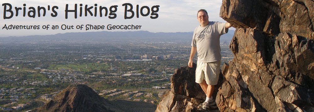
The start of day one began early at the base of South Mountain.  I was lucky enough to have my boss hike with me on this hike.  We met at the trail head - my car and pack were full with 3 liters of water, Gatorade and countless power bars, first aid kit.  My boss - well he has a coffee from Starbucks.

After ditching the coffee and signing in, we began the hike up to the summit.  This hike was 5 miles round trip with 1000 foot elevation gain.  I felt great on this hike.  In no time at all we reached the cold and windy summit for the first check in of the day.  
Knowing I had six summits left, we decided to start hiking down.  I was feeling good so I did some trail running on the way down.  In no time at all the first hike was over and my adventure was underway.


Summit #2 - South Mountain - Ranger / Las Lomitas Trail (Trail Log)

It was a short drive across the preserve to the start of Summit 2.  This was a 3 mile hike with 750 feet in elevation.  After check-in the hike starts out a bit cross country to the base of the hill.


I have to admit, this hike was steep.  After about a mile I started to drop back from my boss and began pacing with another person.  A bit later, I had to drop off from her pace too.  My low gear was gone.  Self-doubt filled my mind while I slowly made my way to the summit.  

The hike down was uneventful.  Hiking down is so much easier.  It's sure is rough on the knees though. more on that later - two summits down, five to go!


Summit #3 - Piestewa Peak (Trail Log for #3 and #4)

It's a 30 minute drive over to the Phoenix Mountains Park and Recreation Area .  I had this time to think about the next hike.  Piestwa Peak is 1 short hike distance wise (1.2 miles to the peak).  The killer part of this hike is the 1200 foot elevation gain.  An extra bonus is that the trail is littered with "steps" that are twice as high as normal steps in your house.  I knew this was the toughest hike and was ready for it.

I took this hike slow and steady.  As I have mentioned in previous blog posts hiking Piestewa Peak is like being on the 405 freeway at rush hour.  There is a mix of hikers, non-hikers and tourists trying to make it to the summit.  Some of these people have no business being on the trail, while others sprint up like their hair is on fire.  

My game plan was to take this hike slow and steady. I set a nice slow pace and tried to stick to it.  All the way up I would pace with different hikers until I could not keep up.  It hurt, it burned - bu eventually I made it to the top.

3 Down - 4 to Go!


Summit #4 - Piestewa Trail 200 (Trail Log for #3 and #4)

This hike was the easiest of the seven hikes and was supposed to be the last hike of my day.  This summit was added to take the place of  this year to take the place of Camelback Mountain.  The parking issues over there are too great to hold an event like the Seven Summits.

This hike was supposed to be a uneventful 1 mile round trip hike with a modest 300 foot elevation gain.  Well, I managed to screw that up.  Somewhere, I went left when I should have gone right.  I ended up climbing a pretty steep mountain face to the summit. When I reached it, the Mountain Rescue guy was laughing at me.  "Are you in the SSOP hike? - Well you win the award for most creative way up to this summit!".   Looking past him I saw the nice, well worn trail I was supposed to take.  OOPS!


Summit #5 - Lookout Mountain (Trail Log)

Lookout Mountain was supposed to be the first hike on Day 2.  I choose to do this hike on day 1 because I was feeling good and I had a time commitment early on day 2.

The "official" map of this summit showed the hike wrapping around the whole preserve with a "detour" up to the summit.  This was a 4.3 mile hike.  I had other plans.

Since the goal of these two days were summits, and I had just hiked the whole park for a geocaching event, I decided to take the direct rout up to the summit.   Is this cheating?  I don't think so!  

I quickly made it to the summit and back down to end day one.  Two hikes left!


Summit #6 - North Mountain- Start of Day 2

I couldn't sleep well between day one and two.  I was a bundle of goo - too excited knowing I was going to accomplish my goal and too sore to rest comfortably.  

I've hiked North Mountain many times before so I knew what to expect here. .  I arrived just as the city was setting up shop, checked-in at the visitor's center and began the hike.   Once you hike over to the main trail, the hike to the summit of North Mountain follows a paved road.  It is a fairly aggressive incline at some points and really take a lot out of me.  This is another popular trail in the middle of Phoenix so you come across people of every shape and fitness level..  Surprisingly I was felling great and quickly made it to the summit.  


I actually arrived before any of the check-in people so I started down without my stamp.  About 1/2 way down I met up with the guy that stamped my passport.  One Hike Left!


Summit #7 - Shaw Butte - The Final Summit

Shaw Butte from the Summit of North Mountain
Coming down from North Mountain, I could see the final summit.  All the way down and across the Phoenix  Preserve, I was walking on air.  Was I really going to finish this?  Well, it wasn't going to come without a fight.  The hike up to Shaw Butte (from the backside) is a bit steep and a challenge.  

Walking on air quickly turned into trying to pace myself up one final incline.  The actual hike up was 750 feet over about a mile.  It was a bit rough, but my adrenaline was flowing.

In no time at all I made it to the summit and got my final stamp.


Next Year, I'm doing the One Day Event!

Completed Passport