Wednesday, February 15, 2012

2012 1-21 Ballantine Trail


Length: 12.9 miles

Duration: 8 Hours 22 minutes

Vertical Up: 3786 feet

My track log at EveryTrail


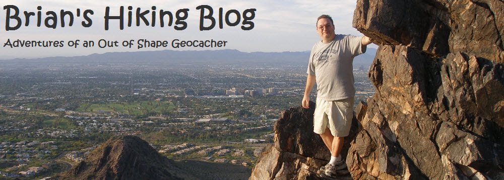
Would you hike 13 miles to discover a Geocache?  This was the question that I was asking myself as I met up with a dedicated group of hikers along the Beeline Highway on a cold January morning.  Although the ultimate goal was not clear to me, I knew the hike was going to be long uphill and have some good views.  


The hike starts out easy enough with a modest 700 foot elevation gain over the first 2 miles.  The trail is very well established and a "easy" hike.  


Around the four mile mark we hit the first goal of the hike, Trojan Horse.  This is a rock formation that looks like a horse. Of course their is a Geocache there.  I was the only one in our group not to have found this cache, so I went to the rock and found it (after a bit of contortionist-like moves).  


From this point on the hike gets, well, interesting.  The climb starts to get serious here and the trail begins to become overgrown.  There are points in this portion where its easy to loose the trail if you are not paying attention.


A few more mile of hiking brought us to our second goal, a rock called "Evil Fish".  Since this was a new location for all of us, we did the cache that was located here.


Now it got fun.  From Evil Fish on, the trail is unbelievably steep and way overgrown.  Pants (not shorts) are a must on this trail and its not uncommon to draw blood on any exposed skin.  The last 1/2 mile of the hike seemed like it was straight up through a forest of bushes and plants that stabbed, poked and did everything it could to prevent us from reaching our goal.


I think it took 45 minutes to hike the last 1/2 mile, but the reward was worth it.  Our turn around poiint was a rock outcropping with a tremendous view of where we came from.  We paused here to eat lunch and began the long trek back.

The 7 mile hike back was more of the same brutality.  The only difference is the downhill slant of the trail reeked havoc on my knees.  Eventually we made it back to the trailhead.  this was a very cool hike, but, one I won't repeat anytime soon.  When I do, It think I'll bring a machete! 


Tuesday, January 3, 2012

2012 1-1 McDowell Mountain Regional Part


Length: 8.4miles

Duration: 4 Hours 31 minutes

Vertical Up: 1319 feet

My track log at EveryTrail


Today’s hike was in the McDowell Mountain Regional Park.  The 21,099-acre has  over 50 miles of hiking/mountain biking  trails and spectacular views of four peaks, Fountain Hills and the Superstition Mountains.  This hike was my first “powertrail” geocache event.  A powertrail is a series of caches are laid out along a roadway or hiking trail in order to log as many finds in as short a distance as possible.

The folks at the McDowell Mountain preserve have been gracious enough to allow a group of geocachers to set up a few powertrail loops around the park.  Roughly 10 geocachers chose today to get together to do some serious caching.  Today’s plan was to do the big loop and get as many caches as possible.


The hike stared off in the Visitor’s center.  As I mentioned above, the employees here are extremely cacher friendly.  The first cache of the day was a mystery cache.  It involved finding answers to three questions in the VC and presenting them to the cashier.  Once we did that, she brought out the cache.  Cool way to start the day.


A quick drive to the trailhead and we were off on the hike.  This particular powertrail had about 10 caches per mile - one approximately every 500 feet.  They were “easily hidden” 35 mm film canister.  We decided on a team name and started out. 

The hike itself was mellow.  It was basically flat (a slight 400 foot elevation gain) and well maintained trail all the way.  The group quickly got into a rhythm of leap frogging caches.  About a ¼ of the way into the hike we spotted 4 deer about 500 feet off the trail.


It was a joy to hike with so many people swapping stories about caches, hikes, hides and people.  In what seemed like no time at all we were at the back of the park, stopping for lunch at a bench overlook. 
As the hike drew on it did become a bit monotonous and (dare I say warm).  If I’ve learned on thing hiking in Arizona it is how to dress in layers.  A few more miles of hiking and we called it quits at the main road.


What a great way to start the New Year!  All total, we found 71 caches!